


LESZCZYCKI Stanisław - Tourist route in the vicinity of Cracow. Concise description with map and 2 illustrations. Kraków 1930 - Oddz. Krakowski Pol. Tow. Krajoznawczego. 8, p. 8. broch.
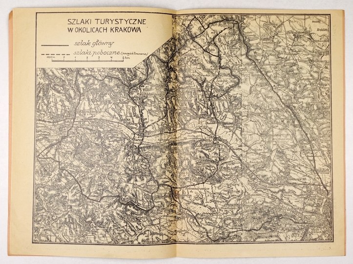
Wraps slightly dusty, good condition."The trail runs out of the city by the Krowoderska turnpike at Łokietka Street, where it can be reached by Sląska Street from the end of Długa Street (where the streetcar line stops) and follows the shortest way half-west to Ojców. At first it runs along the road to Toña, past the military fort, but immediately after passing the once existing tributary of Pr±dnik Czerwony, now a dry valley, it turns into the fields and among the fields and meadows goes straight to the village of Pêkowice. From there it takes the road to Giebułtow (17th century church), and then through a pasture and birch forest to a loess ravine, a minor branch of the Prądnik valley. A peculiarity is a special species of birch trees and beautifully preserved loess formations. From Prądnik Korzkiewski, the trail follows the valley floor up Prądnik to Ojców. Along the way, noteworthy is the great Maszycka cave, and nearby a cave still inhabited today. Further on a number of beautiful rock groups fantastically named by the people, abounding in caves with traces, residence of pre-historic man. On the right side of the road three picturesque gorges branch off: Gypsy Jar, Stodoliska and Korytania. In Ojcow proper, near Krakowska Brama, the trail crosses the highway connecting Krakow and Olkusz. Ojcow, until recently the most beautiful ravine in the area, has been tarnished by a limestone road (hence the clouds of white dust in summer) and the cutting down of fir trees frozen in the last harsh winter. Despite this, however, it still has a number of beautiful nooks and crannies - it is perfectly suited for the "future" suburban park of Krakow [...].


![MAPA KRAKOWA - Umgebungskarte KRAKAU - Vienna ca. 1900 - [owned by Stefan Sapieha].](https://img1.one.bid/img/6265/1864719_1x.webp?1713304800)
![MAPA KRAKOWA - Umgebungskarte KRAKAU - Vienna ca. 1900 - [owned by Stefan Sapieha].](https://img1.one.bid/img/6265/1864719_2x.webp?1713304800)


Recently viewed
Please log in to see lots list
Favourites
Please log in to see lots list