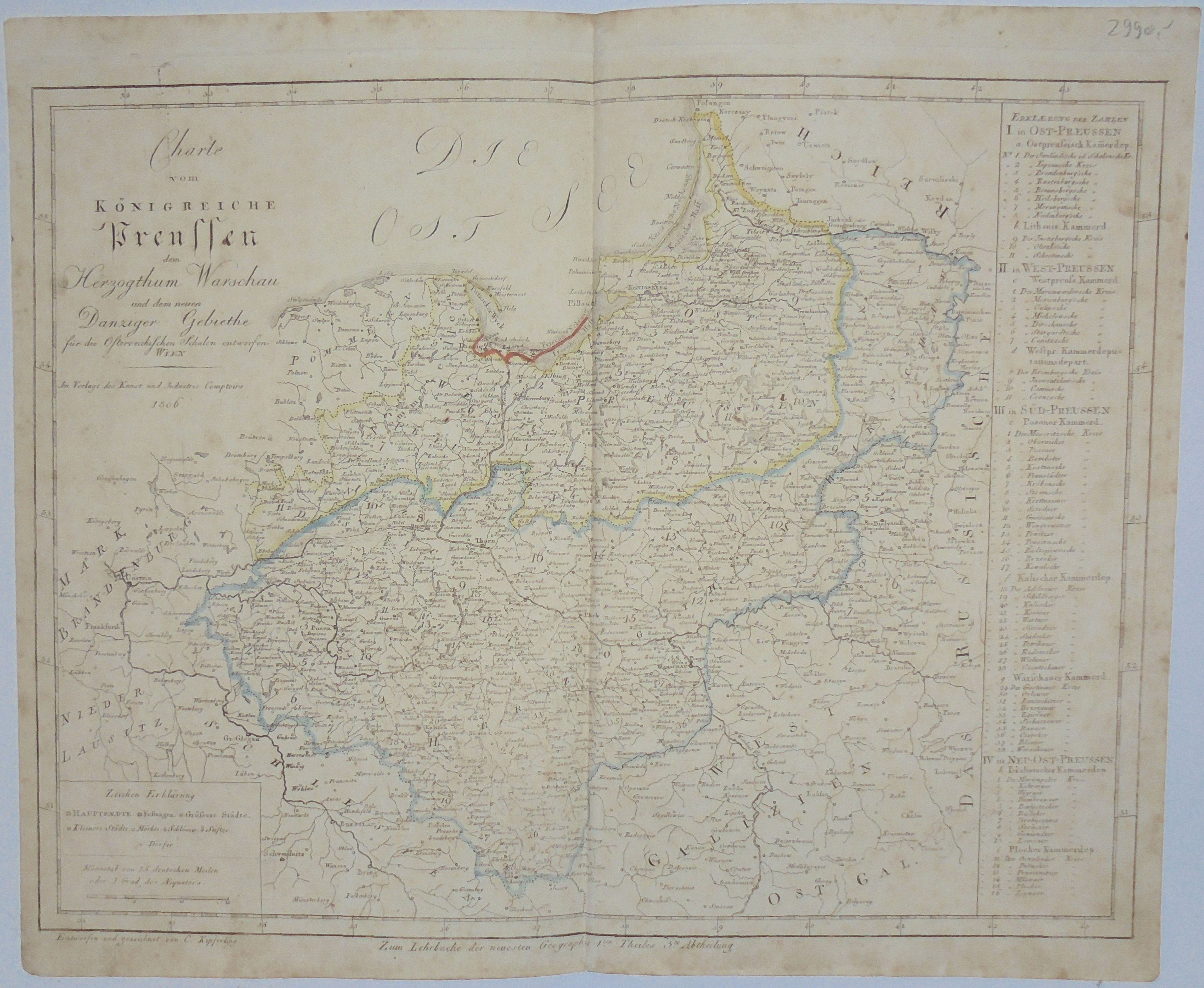
"Charte | vom | Königreiche | Preussen | dem | Herzogthum Warschau | und dem neuen | Danziger Gebiethe | für die Osterreichschen Schulen entworfen.| Wien | Im Verlage des Kunst und Industrie Comptoirs | 1806."
Below the map, on the left, the signature of the draftsman and engraver: Entworfen und Geziechnet von C. Kipferling . Below the map, in the middle, a note: Zum Lehrbuche der neuesten Geographie 1.ten Theiles 3.te Abtheilung.
Original copperplate engraving, line-colored in the period, dated circa 1807, measuring 32.3 x 42.4 cm, on a sheet 36.6 x 44.1 cm. The second known condition (publisher's variant) of at least three (two dated 1806, one dated 1816).
The oldest known publishing variant of this map is an edition dated 1806:
"Charte | vom | Königreiche | Preussen | Nach Herrn Dr. Sotzmann's |neuester Charte | dieses Königreichs zum Gebrauche der österreichischen Schulen entworfen | Wien | Im Verlage des Kunst und Industrie Comptoirs | 1806." , on which the Duchy of Warsaw was not yet marked, the second publishing variant we know of is the one offered here, dated 1806, already with the Duchy of Warsaw marked, probably the plate was quickly corrected just after the peace of Tilsit (or, unlikely, even earlier, anticipating the arrangements of the powers), the third publishing variant we know of is the edition dated 1816(see point b of the bibliography). One of the maps by Friedrich Daniel Sotzmann (1754-1840), the leading German cartographer of the period, was used as a model, which was reworked for school purposes by Viennese cartographer and engraver Karl Joseph Kipferling.
School atlases wore out quickly, so both the atlases themselves and the maps in them are found less frequently than from other types of atlases.
Bibliography:
(a) "Central Catalog of Cartographic Collections in Poland," notebook 6, PAN IGiPZ, Warsaw, 2000, does not note such early editions of Kipferling's Map of Prussia and the Duchy of Warsaw in Polish collections, and does not provide a single one according to the model offered here. - The earliest recorded map of Kipferling's Duchy of Warsaw is item 202 edition dated 1807 (one piece in the Polish collection - in the ZZK BN in W-wa), with another variant dated 1812 noted under item 251 (also one known piece in the BP collection in Paris). Both editions noted in CKZK z.6 depict the pre-partition territories of Poland, with the division between the partitions and the territory of the Duchy of Warsaw, not the very fragment of the Prussian partition and surrounding areas(with poorer content) that is offered here.
- Under items 181 and 183 are noted Kipferling's maps dated 1806 (Galicia and Silesia with Moravia), both with a note like the piece offered here, were included in "Kleiner Atlas der neuen Geographie zum Gebrauche der österreichischen Schulen", which had several editions from 1807 to at least 1816 (the maps were sometimes updated for subsequent editions)-both exclusively in the collection of the Jagiellonian Library.
b) Szaniawska L., "Maps of the Kingdom of Poland issued between 1815 and 1915 in the collection of the National Library in Warsaw," from the series "Studies and Materials from the History of Cartography z. XVI, BN, Warsaw, 1997, item 206 (1816 edition, ref. 14885).
(c) https://sammlungen.ulb.uni-muenster.de/hd/content/pageview/2626025 - Variant No. 1.
Since the CKZK edition in 2000, the situation may have changed - for example, a piece of the edition offered here is in Olsztyn (ref. DH 10261 OMO).
A rarity!