


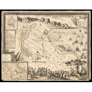
Sébastien Pontault de Beaulieu (1612–1674)
Carte du Gouvernement de Roses ( Catalogna - Spagna
etching, 55 x 43 cm
from "Le glorieuses conquistes de Louis le Grand, Roy de France", printed in Paris, 1659ca. Plan of the land with the bay of Roses and its fortress, besieged by the French in 1645; presents the formation of combat sailing ships at sea and the positions on the ground ,with the soldiers represented below. On the left, a small geographical map of the Gulf of Roses located in the final part of the Pyrenees.
Interesting map, trimmed to the edge of the engraved decorative frame, heavy paper with slight lacks at the corners and edges.


Ostatnio oglądane
Zaloguj się aby zobaczyć listę pozycji
Ulubione
Zaloguj się aby zobaczyć listę pozycji