


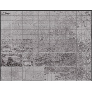
Joseph-Jean François Ferraris (1726-1814)
Carte Chorographique des Pays Bas autrichiens dediee a leurs Majestes imperiales er royales…, 1777
25 sheets. Etching and engraving, 68 x 101 and 68 x 52 cm
An impressive map of the Netherlands, commissioned by Empress Maria Theresa of Austria and Emperor Joseph II. Between 1771 and 1778, Austrian general and cartographer Joseph de Ferraris created this first scientific map of the Austrian Netherlands. The original handwritten designs are kept in the National Library of Belgium. In 1777 the engraved map was published in a total of 25 sheets.
Biblipography:
K. De Coene, T. Ongena, F. Stragier, S. Vervust, W. Bracke, P. De Maeyer, Ferraris, the Legend, "The Cartographic Journal", 49, 2012, pp. 30-42.
Complete edition of 25 sheets, printed on laid paper with watermarks (letters TAMIZIER AUVERGNER 1710 FIN). Sheets in very good condition except for a few with slight tears at the edges and creases.


Ostatnio oglądane
Zaloguj się aby zobaczyć listę pozycji
Ulubione
Zaloguj się aby zobaczyć listę pozycji